For those of you web jockeys that don't know, I have recently become an avid fly fisher. The sport brings together a number of my favorite things into an exciting and elitist format that I can really dig my teeth into. I get to be outside, which is always a good thing. I get to make intricate little flies which brings me back to my modelling days of old. It also lets me "hunt" with an option of not actually killing the animal. So as my new obsession began to take hold, I decided to do something very unlike me. I subscribed to a local chapter of a activist organization, Trout Unlimited.
Trout Unlimited (TU) is a national organization with more than 150,000 volunteers spread across approximately 400 chapters. Many of the members are dedicated conservation professionals including experts, scientist, and even lawyers. They are constantly working towards fishery restoration and widely known for their influences on policy around prominent fisheries across the country. It seems a little conceded though, saying you are saving the country's waterways when really you just want a nice place to fish. But that works for me, and more importantly they get the job done, in a big big way.
How big? Try the largest dam removal project currently being undertaken in the world at a cost of $450 million. Not bad for a grassroots fishing group.
Thursday, March 25, 2010
Thursday, March 18, 2010
Everything Has an Impact
Monday, March 15, 2010
Beekeeping in New York City
Keeping bees in New York City is illegal due to concerns about public safety -- unfounded concerns, according to the many people who keep hives anyway. According to the New York Times, the city may amend the health code this week to permit beekeeping of Apis mellifera:
The New York City Beekeepers Association, brazen lawbreakers that they are, offer 12-hour beginner classes for $100 on their website, as well as a bunch of community information (and puns related to beekeeping).
Thursday, March 11, 2010
Blood-red Waterfall of Primordial Ooze
In Antarctica, there is a blood-red waterfall pouring down five stories from the Taylor Glacier. The water comes from a lake in which an ecosystem of microbes was trapped by the glacier about 2 million years ago. Since then, the organisms have evolved while sealed off from air, light, and most heat. "Primordial ooze" as Atlas Obscura says.
Wednesday, March 3, 2010
Earthquake Shifts Earth's Axis, Speeds Up Rotation
According to NASA scientists, the Earth's axis likely moved by about 3 inches following the major earthquake in Chile on February 27th. Earthquakes can shift the distribution of mass on the planet, changing the way it rotates.
The change is very small -- the length of a day shortened by just a millionth of a second. The quake may have caused some more obvious changes, too, perhaps shifting islands and raising Santa Maria Island (off the coast of Chile) by approximately 6 feet, according to a researcher at Liverpool University.
http://www.businessweek.com/news/2010-03-01/chilean-quake-likely-shifted-earth-s-axis-nasa-scientist-says.html
The change is very small -- the length of a day shortened by just a millionth of a second. The quake may have caused some more obvious changes, too, perhaps shifting islands and raising Santa Maria Island (off the coast of Chile) by approximately 6 feet, according to a researcher at Liverpool University.
http://www.businessweek.com/news/2010-03-01/chilean-quake-likely-shifted-earth-s-axis-nasa-scientist-says.html
Thursday, February 25, 2010
Bloomberg Commits to Water Quality Improvements In Jamaica Bay
It's about time.
The city put out a press release today with some vague details on the new Jamaica Bay water quality improvement plan. While this is a step in the right direction I know I personally would have liked to see more details in the plan. However there is a substantial amount of money being moved into Jamaica Bay wetland restoration which as an avid birder always gets a thumbs up.
The release ran with this opening statement:
"Today marks a new beginning for Jamaica Bay - an amazing recreational and economic resource for New Yorkers," said Lawrence Levine, staff attorney for the NRDC. "The city has committed to address the biggest source of pollution that has plagued Jamaica Bay for decades. We look forward to continuing to work with Mayor Bloomberg and Commissioner Holloway to turn today's historic commitments into reality."
The city put out a press release today with some vague details on the new Jamaica Bay water quality improvement plan. While this is a step in the right direction I know I personally would have liked to see more details in the plan. However there is a substantial amount of money being moved into Jamaica Bay wetland restoration which as an avid birder always gets a thumbs up.
The release ran with this opening statement:
"Today marks a new beginning for Jamaica Bay - an amazing recreational and economic resource for New Yorkers," said Lawrence Levine, staff attorney for the NRDC. "The city has committed to address the biggest source of pollution that has plagued Jamaica Bay for decades. We look forward to continuing to work with Mayor Bloomberg and Commissioner Holloway to turn today's historic commitments into reality."
Labels:
Jamaica Bay,
Mayor Bloomberg,
NRDC,
water,
water quality
Friday, February 19, 2010
Welcome to the Jungle
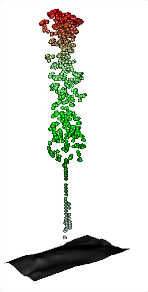
ESRI is a big fan of hammering you with updates about their GIS products as well as updates about the GIS community around the globe. Luckily for me a lot of their publications have environmental undertones which make them less like spam and more like...something useful. In their most recent issue of ArcWatch, I came across a very interesting article about using Lidar technology to map forests; and I don't mean where the forests are, but actually where individual plants are and how big they are.
Lidar stands for Light Detection And Ranging. Without getting into anything too technical, it basically uses pulses of light in the form of lasers to determine the distance to something. This technology has been used a lot to perform remote surveys of large areas to determine elevations and slopes of a landscape. Researchers from Forestry Tasmania have adapted the technology to measure the height of trees and to some degree the amount of foliage that tree has.
Suffice it to say that it is pretty awesome. Especially when you start seeing images of more than 1 plant at a time, you can tell very quickly that this technology will be able to measure a forest's vegetative cover to some extent. Forest managers are already drooling over the prospects.
Check out more details at the ArcWatch article here.
Lidar stands for Light Detection And Ranging. Without getting into anything too technical, it basically uses pulses of light in the form of lasers to determine the distance to something. This technology has been used a lot to perform remote surveys of large areas to determine elevations and slopes of a landscape. Researchers from Forestry Tasmania have adapted the technology to measure the height of trees and to some degree the amount of foliage that tree has.
Suffice it to say that it is pretty awesome. Especially when you start seeing images of more than 1 plant at a time, you can tell very quickly that this technology will be able to measure a forest's vegetative cover to some extent. Forest managers are already drooling over the prospects.
Check out more details at the ArcWatch article here.
Subscribe to:
Posts (Atom)